Aataveanga
A village located near the Palos Verdes Peninsula. (McCawley, 1996)
Achoicominga
Native place/village where the Mission San Fernando Rey de España was founded.
Achois
Achois (also, Achoic Comihauit) is a former Tongva Indian settlement in the San Fernando Valley of Los Angeles County, California.
It was located at Mission San Fernando Rey de Espana, as a Mission Indians rancheria.
map
Name Variations or Other Villages:
-Achoic Comihauit
-Achois Comihavit
Comments:
source: Hoover, Mildred B., et al. Historic Spots in California. 3rd edition. Stanford, California: Stanford University Press, 1966. p163
Achooykomenga
Native place/village where the Mission San Fernando Rey de España was founded.
map
Name Variations or Other Villages:
-Pasheeknga
-Achooykomengna
-Achoiscomihabit
-Achoicominga
-Achoycomihabit
Notes from Hugo Reid’s letters of 1852.
(Edited and annotated by Robert E. Heizer):
San Fernando Mission baptismal register gives this as , etc. There are 14 entries dating from 1797-1804. It is probably the same name as Reid’s Pasecgna further on in this list and identified with him as “San Fernando.” It is not the native village at the mission, however, since in the introduction to the San Fernando baptismal record it is stated that the “mission was founded in the place called by the natives Achoiscomihabit .”
Acuragna
Acuragna is a former Tongva-Gabrieleño Native American settlement in Los Angeles County, California Exact location is unknown. (The Presa/La Presa)
Agoura Hills, California
The area was first settled by the Chumash/Gabrielino Native Americans around 10,000 years before present. As the Alta California (Upper California) coast was settled by Spanish  Franciscan missionaries in the late 1700s, the El Camino Real (the Royal Road or King’s Highway), a road from Loreto, Baja California, Mexico to Sonoma, California, and connecting the Spanish missions in California, was established through the heart of what would later be known as Agoura Hills.
see: http://en.wikipedia.org/wiki/Agoura_Hills,_California
Ahapchingas
Ahapchingas is a former Tongva-Gabrieleño Native American settlement in Los Angeles County, California. It was located between Los Angeles and San Juan Capistrano; its precise location is unknown.
Ahau
Located somewhere near the Los Angeles River. No other information available at this time.
Ahura
A Gabrielino-Tongva site. More information coming.
Ahwaanga
Ahwaanga was a coastal village located near the Los Angeles River and within the city boundaries of Long Beach.
http://en.wikipedia.org/wiki/Long_Beach,_California
Ahmutskupiangna
A Tongva village in the Cajon Pass.
Ajaarvongna
A name for Puente Hills and/or a Tongva village.
Akuranga
Near Pasadena and/or San Gabriel Mission. (La Presa)
Name Variations or Other Villages:
-Akurongna – near San Marino
-Akura
-Akuuranga
-Akurangna
Aleupkinga
A former Tongva-Gabrieleño Native American village in the County of Los Angeles, California. It was located at Santa Anita / Arcadia, CA in the San Gabriel Valley.
NO. 368 HUGO REID ADOBE – Hugo Reid, a Scotsman, petitioned the government of Mexico to grant him Rancho Santa Anita. His claim strengthened by his marriage to Victoria, a native Indian of the San Gabriel Mission, he received the grant on April 16, 1841. Immediately upon filing his petition, Reid took possession of the land, started to farm and plant vineyards, and built the first house-the Hugo Reid Adobe-in 1839. In 1875, E. J. Baldwin purchased the rancho and in 1879 added a wooden wing to the old adobe.
Location: Los Angeles State and County Arboretum, 301 N Baldwin Ave, Arcadia
map
Name Variations or Other Villages:
-Aleupkinga…hb
-Aleupkigna
-Aleupkingna
-Alyeupkigna
-Almpquigna
-Rancho Santa Anita
Amaunga
A village located near Bixby Knolls and Long Beach. No other information available at this time.
Amuscopopiabit
The baptismal records from the San Gabriel Mission lists this village and 70 as the number of converts. (1777-1815)
Name Variations or Other Villages:
-Moscopiabit
Amupunga
A village located near Compton, CA.
Amutskupinga
A village located near Cajon Junction in the San Bernardino Mountains.
Anaheim, California
The village of Hotuuknga was located here.
Name Variations or Other Villages:
-Hotuuknga
see: http://en.wikipedia.org/wiki/Yorba_Linda,_California
Apachianga
The village was located near the City of Los Angeles and Boyle Heights.
Name Variations or Other Villages:
-Apachia
Ashaawanga
The Tongva village located near Chatsworth.
Ashuuksanga
A location in Asuza, CA.
Name Variations or Other Villages:
-Asuksangna
-Asuksa
Ataavyanga
A coastal village on the Palos Verdes peninsula.
Name Variations or Other Villages:
-Ataavayngna
-Atavayangna
Atavsangna
A Tongva village located near Burro Flats.
Awingna
Awingna (also, Awizna) is a former Tongva-Gabrieleño Native American settlement in Los Angeles County, California.
It was located at the site of modern-day La Puente, in the San Gabriel Valley.
map
Name Variations or Other Villages:
-Ahwingna
-Awigana
-Awigna
-Ajuinga
-Awizna
-Ajuibit
Awiinga
A village near La Puente, CA.
Name Variations or Other Villages:
-Awi
-Awigna
Azucsagna
Azucsa-gna (also, Asucsa-gna) is a former Tongva-Gabrieleno village located in Azusa, CA.
Name Variations or Other Villages:
-Asuksanga
-Asucsagna
-Asuksa
-Asucsagnas
-Asucsabit
-Acuzabit
Azusa, California
The village of Asuksangna was located here.
see: Asucsagna, Asuksagna
Balboa, California
The Tongva village of Mayongna was located here.
Ballona Wetlands
The Ballona Wetlands are located in Southern California, USA south of Marina del Rey and east of Playa del Rey. The wetlands once included the areas now taken up by Marina del Rey, Venice, and Playa Vista, extending north to about present-day Washington Blvd. in Venice.
Many Tongva villages existed in the Ballona Wetlands area (Culver City, Santa Monica) of Los Angeles where the river meets the sea.
http://en.wikipedia.org/wiki/Ballona_Wetlands
Bell Canyon, California
Chumash Native Americans lived in the canyon, research shows, for around 8,000 years. The Chumash had the village of Hu’wam here in the canyon on Bell Creek upstream from Escorpión Peak. It was multi-cultural, where Chumash, Tongva, and Tataviam peoples lived and traded together. Nearby is the Burro Flats Painted Cave.
http://en.wikipedia.org/wiki/Bell_Canyon,_California
Beverly Hills, CA
NO. 665 PORTOLÁ TRAIL CAMPSITE, 2 – The expedition of Don Gaspar de Portolá from Mexico passed this way en route to Monterey to begin the Spanish colonization of California. With Captain Don Fernando Rivera y Moncada, Lieutenant Don Pedro Fages, Sergeant José Francisco Ortega, and Fathers Juan Crespí and Francisco Gómez, Portolá and his party camped near this spot on August 3, 1769.
Location: 325 South La Cienega Blvd between Olympic and Gregory, Beverly Hills
BLACK STAR CANYON
A Tongva settlement in the Santa Ana Mountains.
Bolsa Chica Ecological Reserve
Huntington Beach, California
Bolsa Chica Ecological Reserve is a nature reserve in the city of Huntington Beach, California, The history of Bolsa Chica is a long and varied one. The earliest peoples were the Tongva Indians of California. Archaeologists have found cog stones which date back 8,000 years and are the only surviving relic of the Indian lifestyle. Their exact purpose is unknown, but speculation has centered on religious or astronomical use. Cog stones can be seen at the Bowers Museum in Santa Ana.
http://en.wikipedia.org/wiki/Bolsa_Chica_Ecological_Reserve
Burro Flats Painted Cave, California
Simi Valley, California
Area of: Chatsworth, Canoga Park, Agoura Hills, Calabasas
Simi Valley is an incorporated city located in a valley of the same name in the southeast corner of Ventura County, California, bordering the San Fernando Valley of Los Angeles in the Greater Los Angeles Area.
The cave is located near the historic Chumash settlement of Hu’wam, along upper Bell Creek, and Tongva/Fernandeño settlement Misión Vieja and Atavsangna.
The Burro Flats pictographs have been termed “the best preserved Indian pictograph in Southern California.” Archaeologists estimate the drawings are several hundred years old. There is a replica of the pictographs at the Southwest Museum in Highland Park, Los Angeles.
One theory about the drawings is that they were a cooperative effort between the Chumash and Gabrielino tribes in the 1400s to celebrate the solstice and friendship between the two tribes.
http://en.wikipedia.org/wiki/Burro_Flats_Painted_Cave
“Perhaps the most detailed description of condor ceremony in southern California comes from the Panes (or bird) festival of the Luiseño. It was described by Friar Boscana of Mission San Juan Capistrano and by Friar Peyri of Mission San Luis Rey in the early 19th century. Similar ceremonies were held by the Gabrieliño, Cahuilla, Kumeyaay and Cupeño (Kroeber 1907; 2002)”.
Click here for rock art video.
http://www.parks.ca.gov/?page_id=23527
Cahuenga, California
A Tongva Village was once located here.
http://en.wikipedia.org/wiki/Cahuenga,_California
Cahuenga
Cahuenga is a former Tongva village near the San Fernando Mission in the San Fernando Valley.
Its precise location is unknown.
The name was used for the historic Mexican land grant Rancho Cahuenga.
The name survives in Cahuenga Pass between the Valley and Hollywood, Cahuenga Boulevard, and Campo de Cahuenga in Studio City, California, where the Treaty of Cahuenga was signed.
Name Variations or Other Villages:
-Cabeugna
-Cabuenga
-Cahuegna
-Cahuenga
-Cahugna
-Caliuenga
-Cabuepet
-Okowvinjha
-Kowanga
-Kaweengna
-Kawengna
Chaawvenga
A village located near the Palos Verdes Peninsula. (McCawley, 1996)
Okowvinjha
A former Gabrieleno rancheria near San Fernando mission,
Los Angeles co., Cal. (Taylor in Cal. Farmer, May 11, 1860) . Probably identical with Kowanga or with Cahuenga.
Carpenter’s Ranch
The village was located near La Habra, CA. (Carpenter’s Ranch)
Rancho Santa Gertrudes was a 21,298-acre (86.19 km2) 1834 Mexican land grant, in present day Los Angeles County, California resulting from a partition of Rancho Los Nietos. A former site of Nacaugna, the rancho lands included the present day cities of Downey and Santa Fe Springs.
http://en.wikipedia.org/wiki/La_Habra,_California
Name Variations or Other Villages:
-Nakaunga…hb
-Nacaugna…reid
-Nicaugna
-Nakaungna
Nacau-gna: A Gabrieleno rancheria formerly in Los Angeles co., Cal., at a place later called Carpenter s ranch. Nacaugna. Reid quoted by Taylor in Cal. Farmer, Jan. 11, 1861
Ceegenga
The village was possibly located in the Granada Hills, CA area near Aliso Canyon Wash.
“Currently the city of LA is developing within the confines of Aliso Canyon in the city of Granada Hills. As you well know this canyon was home to 6-14 Tongva Indians from the village of Ceegenga or Sasabenga who were removed from Aliso canyon between 1797-1802 — email contribution 9-06-12, from Dustin Lorentz (Scholar/Anthropoligist)
Aliso Creek (also Aliso Canyon Wash or Aliso Wash) is a major tributary of the Los Angeles River in Los Angeles County, California, with a watershed of 21 square miles (54 km2).[2] It is the second major tributary to enter the Los Angeles River downstream of the Bell Creek/Calabasas Creek merge.[3] The stream runs about 10 miles (16 km) from Aliso Canyon below Oat Mountain to its confluence with the Los Angeles River. During its first mile, it is a free-flowing stream mostly contained within Aliso Canyon Park and Eddlestone Park.
http://en.wikipedia.org/wiki/Aliso_Creek_(Los_Angeles_County)
Name Variations or Other Villages:
–Sasabenga
Cerritos, California
Cerritos was originally inhabited by Native Americans belonging to the Tongva (or “People of the Earth”) tribe. Later, the Tongva would be renamed the “Gabrieleños” by the Spanish settlers after the nearby Mission San Gabriel Arcangel. The Gabrieleños were the largest group of Southern California Indians as well as the most developed in the region. The Gabrieleños lived off the land, deriving food from the animals or plants that could be gathered, snared, or hunted, and grinding acorns as a staple.
Beginning in the late 1400s, Spanish explorers arrived in the New World and worked their way to the California coast in 1542. The colonization process included “civilizing” the native populations in California by means of establishing various missions. Soon afterwards, a town called El Pueblo de Nuestra Señora la Reina de los Ángeles de Porciúncula (Los Angeles today) would be founded and prosper with the aid of subjects from New Spain and Native American labor.
see: http://en.wikipedia.org/wiki/Cerritos,_California
Chaawvenga
The village was located in the Palos Verdes and San Pedro area.
Name Variations or Other Villages:
-Chaawvengna
Chaguayanga
A village located at Castaic Junction.
Variation:
Chaguayabit
Chatsworth, California
Village of “Stoney Point” was located here by the Tongva.
Chibugna
The San Fernando Mission registry identifies this village as once located near Bell Gardens, California…near the Los Angeles River..
Name Variations or Other Villages:
-Chibubit
-Chibuna
-Chokiishnga
-Chokishgna
-Chokiishgna – Santa Fe Springs
-Chokishngna
-Chokisgna
Chokishngna
A village located in Jaboneria near El Monte. There was a soap factory…hb
Chowiinga
A village was located in the Palos Verdes area.
Name Variations or Other Villages:
-Chowi
-Unaungna
-Chowingna – near San Pedro
-Chowigna
Chowigna Plaque – 
Comicranga
A village located near the San Gabriel Mission.
Name Variations or Other Villages:
-Comicrabit
Cucamonga
A former village located in the San Gabriel Valley of Los Angeles County, California.
Its precise location is unknown except near Cucamonga, CA/Cucamonga Farm.
Name Variations or Other Villages:
-Cucumogna
-Cucumonga
-Cucamungabit
-Cucamobit
-Cucamobuit
-Cucomogna
-Coco Mongo
-Kuukaamonga
-Kukamongna
-Kukamo
Culver City, California
“The Gabrielino Indians were Culver City’s first residents. They were of Shoshonean linguistic stock, and their tribes occupied the Los Angeles area, north of Ventura, down to Riverside and San Bernardino, Orange County and across to the San Clemente Islands. They were a peaceful people, loving to one another and who did not believe in the destruction of human beings, and consequently do not have things to hurt bodies or minds.” read more:
By Culver City Historian, Julie Lugo Cerra
http://www.visionquest.tv/culver/CCN/History/History.html
see: Huachongna
Dodger Stadium
In 1962, the Dodgers played their first game at Dodger Stadium in Los Angeles. The bums lost, but it may have been caused by the bad karma at Chavez Ravine.
Chavez Ravine in Los Angeles has been many things: a Tongva Indian village, a cattle ranch, a hospital for smallpox victims, and a residential neighborhood, mostly Hispanic.
Built in the Los Angeles community of Chávez Ravine in Sulfur Canyon, the stadium overlooks downtown Los Angeles and provides views of the city to the south, the green tree-lined hills of Elysian Park to the north and east, and the San Gabriel Mountains beyond the outfield pavilions.
Downey, California
Prior to the arrival of the Spanish in Alta California, the area that now comprises Downey was inhabited by the Tongva ethnic group, which came to be called the Gabrielino by the Spanish.
Rancho Santa Gertrudes was a 21,298-acre (86.19 km2) 1834 Mexican land grant, in present day Los Angeles County, California resulting from a partition of Rancho Los Nietos. A former site of Nacaugna, the rancho lands included the present day cities of Downey and Santa Fe Springs.[1][2]
see: http://en.wikipedia.org/wiki/Downey,_California
see: Naxaawngna or Sehat
El Segundo, CA
The El Segundo and Los Angeles coastal area was first settled by the Tongva (or Gabrieleños) and Chumash Native American tribes hundreds of years ago.
see: http://en.wikipedia.org/wiki/El_Segundo,_California
Elysian Park
NO. 655 PORTOLÁ TRAIL CAMPSITE (I) – Spanish colonization of California began in 1769 with the expedition of Don Gaspar de Portolá from Mexico. With Captain Don Fernando Rivera v Moncada, Lieutenant Don Pedro Fages, Sgt. José Francisco Ortega, and Fathers Juan Crespí and Francisco Gómez, he and his party camped near this spot on August 2, 1769, en route to Monterey.
Location: Elysian Park entrance, NW corner of N Broadway and Elysian Park Dr, Los Angeles
Name Variations or Other Villages:
-Maungna
Encino, CA
A village known as Siutcanga.
Engvangna
A village near Rodondo Beach, CA.
Name Variations or Other Villages:
-Engva
-Engovangna
Gardena, California
Based on archaeological findings, Tongva Indians hunted and fished in the area of today’s Gardena.The Tongva Indians — also known as Gabrielino Indians — are probably descendants of those who crossed from Asia to North America around 10,000 years ago.
see: http://en.wikipedia.org/wiki/Gardena,_California
Geveronga
A lost village only known by name and located somewhere near the Los Angeles River and Yanga. No further information available at this time.
Giringa
A possible Tongva village in the Antelope Valley.
Guichi
A village located near San Gabriel, CA.
Name Variations or Other Villages:
-Rancheria Guichi
Guinguina
A village located on San Clemente Island
Name Variations or Other Villages:
-Guiguipat
-Guinquipat
-Guasna
-Guaschna
-Guaaschna
See San Clemente Island
Hahamogna
A village site that was once located near Pasadena, CA possibly in the location of the Jet Propulsion Laboratory.
The Hahamogna inhabited the Arroyo Seco around Pasadena and Altadena, California in the San Gabriel Valley of present day Los Angeles County. They have also been called Pascual.
The name Hahamongna is now applied to Hahamongna Watershed Park, a recreational and open space area of the Arroyo Seco in Pasadena.
see; http://en.wikipedia.org/wiki/Hahamog-na
http://www.cityofpasadena.net/History.aspx
Name Variations or Other Villages:
-Hahamo
-Pascual
Hahamongna
Another site with a similar spelling was located in present-day Glendale.
Name Variations or Other Villages:
-Haahamongna
Harasgna
A former village in the Los Angeles Basin. Location is unknown.
Name Variations or Other Villages:
-Haraasnga
Haramoknga
A village that was located near Pasadena, CA.
Harashngna
The name of San Nicholas Island and/or a Tongva village.
Hawthorne, California
Hawthorne’s first known residents were Indians of the Shoshonian linguistic group, occupying the South Bay, Los Angeles area as early as the 1500s.
see: http://en.wikipedia.org/wiki/Hawthorne,_California
Homhoangna
The name of the city of Colton and/or a Tongva village.
Honmoyausha
Research underway for location in Los Angeles County.
Horuuvngna
A Tongva village located in Jurupa.
Houtnga
The village was located near the San Gabriel Mission. (Ranchito de Lugo)
Name Variations or Other Villages:
-Hout
Hotuuknga
The village was located near Anaheim, Santa Ana and the Santa Ana River.
(La Habra/Yorba Linda )This area was the home of the Luiseno, Tongva, and Juaneño Indians at one time.
Name Variations or Other Villages:
-Hotuuk
-Hutuk
-Hutuc-gna
-Hutukn-gna ..near La Habra/Yorba Linda
see: http://en.wikipedia.org/wiki/Yorba_Linda,_California
Houtngna
A village located in the El Monte area.
Huachongna
A village located in the Culver City area.
Huunga
A village that was located near the Watts/Compton, CA area.
Name Variations or Other Villages:
-Huutngna
-Huutnga
-Hutuk
-Hotuuk
Hyperion
A Gabrielino-Tongva site. More information coming.
Isantkanga
The village located near Aliso Creek and Mission Vejo, CA. as per Hand Book of Indians of California. Original location of the San Gabriel Mission. (1771)
Name Variations or Other Villages:
-Isankanga
-Isankangna
-Isanthcogna
-Isantcanga
-Isanthcagna
-Iisanchanga
-Isantkanga
History: Gabrieleno settlement
Description: Was located at Mission Vieja
Citation: Smithsonian Institution, Bureau of American Ethnology. Washington, DC: Government Printing Office. Bulletin 30 – Handbook of American Indians North of Mexico, Edited by Frederick Webb Hodge, part 1 published in 1907, part 2 published in 1910. Use either code US-T142/B30/PT1/1907/p# or US-T142/B30/PT2/1910/p#. B30/pt1/1907/p622
http://en.wikipedia.org/wiki/Isanthcogna,_California
Jaboneria
The village was located on the west bank of the Rio Hondo River south of Telegraph Road
Jajamonga
Near the Los Angeles River.
Name Variations or Other Villages:
-Jajamonga
-Jajamobit
-Jajamovit
-Haahamonga
Joatngna
A village in the Mt. Baldy area.
Name Variations or Other Villages:
-Yoat
-Joat
-Joatngna
Jucjauynga
A Tongva village located near Burro Flats. (El Escorpion)
Juyubit
The village was near the San Gabriel Mission and the San Gabriel River.
A narrative legend/story mentions Tongvan heroine Toypurina and this location.
Name Variations or Other Villages:
-Jujubit
-Jutucubit
-Jutucuvit
-Jutubit
-Jutucunga
-Utucubit
-Otocubit
-Uchubit
-Ychubit
-Uchunga
Juyunga
A village in the Santa Susan Mountains.
Kaawchamangna
The name for the city of Redlands and/or a Tongva village.
Kawe
A Gabrielino-Tongva site. More information coming.
Kecheek
A location in Santa Monica.
Kengaa
A coastal village near Newport Beach, CA.
Kenyaanga
A coastal village located near Newport Beach, CA.
Name Variations or Other Villages:
-Kenyaangna
Kiingkenga*
A village on the Palos Verdes Peninsula.
Name Variations or Other Villages:
-Kinkingna
-Kiinkenga
*Two locations with the same name
Kiingkenga*
A village on San Clemente Island.
Name Variations or Other Villages:
-Kinkingna
-Kiinkenga
*Two locations with the same name
Kinkipar
The name of San Clemente Island and/or a Tongva village.
Name Variations or Other Villages:
-Kinki…hb
-Kinkipar…hb
-Kimki
-Kiinke Paar
-Kinkingna
-Kiingkenga
Kokomcar
A possible village near the San Fernando Mission. Exact location unknown.
Komiicranga
A village located east of the Malibu area which is considered to be the most northern coastal boundary of the Gabrielinos.
The Humaliwo village of the Chumash was located at the foot of Malibu Canyon.
-Komiicrangna
….. http://www.ci.malibu.ca.us/
Kowanga
It was located near the Mission San Fernando Rey de España.
Name Variations or Other Villages:
-Owongos
-Kowagna
Kuukaamonga
See Cucamonga entry.
Kuruvungna
Sacred site and village located in West Los Angeles, CA/Santa Monica, CA. University Senior High School and the Serra Springs is located here. (California Historical Landmark) – see 1769 expedition
Name Variations or Other Villages:
-Kuruvanga
-Kuruvugna
La Brea, CA
NO. 170 HANCOCK PARK LA BREA – The bones of thousands of prehistoric animals that had been entrapped during the Ice Age in pools of tar that bubbled from beneath the ground were exhumed from this site. First historic reference to the pools, part of the 1840 Rancho La Brea land grant, was recorded by Gaspar de Portolá in 1769 – first scientific excavations were made by the University of California in 1906. The site was presented to the County of Los Angeles in 1916 by Captain G. Allan Hancock to be developed as a scientific monument.
Location: Hancock Park, 5801 Wilshire Blvd between Ogden and Curson Sts, Los Angeles
La Presa, CA
A Gabrielino-Tongva site. More information coming.
Long Beach, California
Indigenous people have lived in coastal southern California for at least ten thousand years. Over the centuries, several successive cultures inhabited the present-day area of Long Beach. By the time Spanish explorers arrived in the 16th century, the dominant group were the Tongva people. They had at least three major settlements within the present day city boundaries. Tevaaxaanga was an inland settlement near the Los Angeles River, while Ahwaanga and Povuunga were coastal villages. Along with other Tongva villages, they were forced to relocate in the mid 1800s due to missionization, political change, and a drastic drop in population from exposure to European diseases.
http://en.wikipedia.org/wiki/Long_Beach,_California
Lopuuknga
The village was located near Costa Mesa and the Santa Ana River.
Los Angeles County
Gabrielino villages existed throughout the Los Angeles Basin. When Cabrillo arrived in 1542 in San Pedro Bay, he called the land the “Bay of Smokes” because he saw so many village fires inland.
Los Feliz, Los Angeles
A Gabrielino-Tongva Indian Site at Fern Dell Canyon near Griffith Park. Historical Cultural Monument No. 112.
Lukupangna
A village located near the mouth of the Santa Ana River/Huntington Beach.
Name Variations or Other Villages:
-Lukupa
-Lukup
Maalewonga
A village located near Malibu, CA.
Maasavnga
A village located around the Palos Verdes Estates.
Name Variations or Other Villages:
-Masau
-Masou
-Massavngna
-Masaugna
Mapipinga
A village located near the San Fernando Mission.
Maugna
A village located at Rancho Los Felix and Hollywood area. And/or Elysian Park
Name Variations or Other Villages:
-Maungna
-Maawnga
-Moonga
-Moomga
-Momonga
-Maugna
-Mau
-Mauga
Maywood, CA
The land on which Maywood now stands had been populated by Native American tribes for centuries. After Spain took over California, the slightly more than a square mile of undeveloped property, was originally deeded in 1781 by the monarchy, to Spanish War veteran Manuel Nieto. When the settlement of Pueblo de Nuestra Senora de Los Angeles was recorded, it included the cow pasture that as eventually turned into a rancho.
see: http://en.wikipedia.org/wiki/Maywood,_California
Mission Vieja
A Gabrielino-Tongva site. More information coming.
Momwahomomutngna
A village located in the San Dimas and Glendora area.
Name Variations or Other Villages:
-Momwahomomutnga
-Momwahmomutngna
Moniikanga
A village located on the Palos Verdes Peninsula.
Name Variations or Other Villages:
-Moniikang
Monrovia, California
Monrovia is the fourth oldest general law city in Los Angeles County and the L.A. Basin (after Los Angeles, Santa Monica, and Pasadena). Incorporated in 1887, Monrovia has grown from a sparse community of orange ranches to a residential community of 37,000. People traveling between Los Angeles and San Bernardino traveled “via Monroe’s Ranch,” hence the name.
Around 500 BC, a band of Shoshonean-speaking Indians established settlements in what is now the San Gabriel Valley. These native Americans came to be called the Gabrieliño Indians by early Spanish explorers, and are now referred to as the Tongva. The Tongva were not farmers; they gathered wild seeds, berries, and plants along rivers and in marshlands. Abundant oaks in the Valley, such as Coast Live Oak and Interior Live Oak provided a staple of the Tongva diet: acorn mush made of boiled acorn flour.
see:http://en.wikipedia.org/wiki/Monrovia,_California
Monterey Park, California
For at least seven thousand years the land was populated by the Tongva (Gabrielino) Native Americans. The Tongva lived in dome like structures with thatched exteriors, an open smoke hole for ventilation and light at the top. Both sexes wore long hair styles and tattooed their bodies. During warm weather the men wore little clothes but the women would wear minimal skirts made of animal hides. During the cold weather they would wear animal skin capes and occasionally wore sandals made from hide of yucca fiber. With the arrival of the Spaniards, Old World diseases killed off many of the Tongva, and by 1870 very few Native-Americans had survived.
see: http://en.wikipedia.org/wiki/Monterey_Park,_California
Motuucheyngna
A Tongva village located in the Seal Beach area of Long Beach.
Moyonga
A village site located near Corona Del Mar.
Name Variations or Other Villages:
-Moyo
Mt. Baldy
Mount Baldy, or Old Baldy, rises to 10,688 feet and is the highest peak in Los Angeles County. Mount Baldy, which also is known by its formal name Mount San Antonio, is part of the San Gabriel Mountains and located in the San Bernardino National Forest. It once was home to the Tongva Indian tribe and was the site of scientific experiments. It’s now a popular hiking area and ski resort.
read more at:
http://www.ehow.com/about_5409445_history-mount-baldy.html
Name Variations or Other Villages:
-Yoat
-Joat
-Joatngna
Mt. Wilson
Mount Wilson is one of the better known peaks in the San Gabriel Mountains, part of the Angeles National Forest in Los Angeles County, California.
There are Tongva trails on the flanks of Mt. Wilson: Lower Winter Creek Trail from the Gabrielino Trail to Hoegees Trail Camp; Gabrielino Trail from Chantry Flat to Red Box continuing along the Arroyo Seco to Altadena.
Muhunga
A village located near the Sylmar, CA area.
Also near the original Los Encinos Rancho that became the Mission San Fernando Rey de España and near Sunland, in the San Fernando Valley.
Name Variations or Other Villages:
-Muuhungna
Muhuvit
A village near the San Fernando area.
Legend ………. In the Lodge of Muhuvit , which lay behind the hills of San Fernando, once lived a chief connected with the following legend, who was a great wizard and enchanter….see Hugo Reid document.
Mujunga
A village located just east of the San Fernando Mission.
Mutuucheynga
A village located near the Long Beach / Seal Beach area.
Naayxoxar
A village located at Isthmus on Santa Catalina Island.
Najabatanga
A Tongva village located near Piru Creek.
Nakaunga
The village was located near La Habra, CA. (Carpenter’s Ranch)
Name Variations or Other Villages:
-Nakaunga…hb
-Nacaugna…reid
-Nicaugna
-Nakaungna
Nacau-gna: A Gabrieleno rancheria formerly in Los Angeles co., Cal., at a place later called Carpenter s ranch. Nacaugna. Reid quoted by Taylor in Cal. Farmer, Jan. 11, 1861
Navungnaa
A village located near the Palos Verdes Peninsula. (McCawley, 1996)
Naxaawnga
The village was located near the Downey area.
Name Variations or Other Villages:
-Sehat
-Naxaawngna
Okowvinjha
A village located near Mission San Fernando Rey de Espana in the San Fernando Valley.
Ochuunga
Location unknown at this time. Map shows in the San Fernando area.
Ongoovanga
A village located near Redondo Beach, CA
Ongobehangna
A village located near Malibu, CA.
Otsunga
A village that was located in the heart of Los Angeles and close to Alhambre.
Pacoima, Los Angeles
Pacoima’s first inhabitants were the semi-nomadic Tongva and Tataviam Native American tribes; the name Pacoima comes from the Tataviam (or Fernandeño) language. In 1797, Spanish colonists built the nearby Mission San Fernando Rey, but the Pacoima area remained without permanent settlement until 1887.
http://en.wikipedia.org/wiki/Pacoima,_Los_Angeles,_California
Name Variations or Other Villages:
-Pakooyngna
Pahav
A village located southeast of Corona.
Pakooyngna
The name for city of Pacoima and/or a Tongva village.
Pamajam
A village located near Corona, Silverado and near the Santa Ana Mountains.
Pasbenga
A village located near Santa Ana, CA and the Santa Ana River.
Name Variations or Other Villages:
-Pasbengna
Pasecgna
A village located near the San Fernando Mission.
Name Variations or Other Villages:
-Pascegna
-Pasheeknga
-Pasheekngna
-Pasheckna
-Passenga
-Passanga
-Pachanga
-Patzanga
Notes from Hugo Reid’s letters of 1852. (Edited and annotated by Robert E. Heizer):
San Fernando Mission baptismal register gives this as , etc. There are 14 entries dating from 1797-1804. It is probably the same name as Reid’s Pasec-gna further on in this list and identified with him as “San Fernando.” It is not the native village at the mission, however, since in the introduction to the San Fernando baptismal record it is stated that the “mission was founded in the place called by the natives Achoiscomihabit .”
Passinonga
A village located in the Chino Hills of Chino, CA in San Bernardino County.
(Rancho del Chino)
Name Variations or Other Villages:
-Pasino
-Pasinogna
-Passinogna
-Pasinpgna
-Passinongna
Pasinpgna
A former Gabrieleno rancheria later called Rancho del Chino
-Pasinogna. Ried (1852)
-Passino-gna
Pavunga
A Gabrielino-Tongva site. More information coming.
Paxauxa
A village was located in Riverside County near Norco, CA
Pear Orchard
A Gabrielino-Tongva site named Sisitkanonga.
Pemookangna
The village was located near Walnut, CA. and La Puente, CA
Perrooksnga
The village was located near La Puente, CA and the San Gabriel River.
Piinga
A possible Tongva village.
Pimokanga
The village was located at the Andrés Ybarra “Ybarra Ranch” in the Los Angeles area, just east of Burbank. (Rancho de los Ybarras)
Name Variations or Other Villages:
-Pimocagna
-Pimocagna
-Pinioocagna
-Pimokanga…hb
Pimu
Santa Catalina Island
Other:
-Pemu
-Pipimar…hb
-Pimu…hb
-Pimu-gna
-Pimunga
Pineu-gna
A village on Santa Catalina Island.
Pipiimar*
A village on Santa Catalina Island on the Avalon side of the island.
Name Variations or Other Villages:
-Pimu (name of island and/or a village)
-Pipimar
-Pimunga (name of island and/or a village)
-Pimubit
-Pumu-ga
-Pimuunam
-Piimua
Pipiimar*
May have also been a village in San Gabriel with the same name.
Pisek
A Gabrielino-Tongva site. More information coming.
Pomona, California
The area was originally occuppied by Gabrielino-Tongva Indians.
See: Toibinga
Puvungna
Puvungna was a coastal village located near the Los Angeles River and within the city boundaries of Long Beach. (Bixby Hill near Cal State Long Beach)
The Tongva people had at least three major settlements in Long Beach: Tevaaxaanga was an inland settlement near the Los Angeles River, while Ahwaanga and Puvungna were coastal villages.
Name Variations or Other Villages:
-Puvuunga
-Puvungna – Long Beach/Alamitos
-Puvunga
-Povunga
-Povuunga
-Puvungva
In or close to these Ranchos:
-Rancho Los Nietos
-Rancho Los Cerritos
-Rancho Los Alamitos
Povomeparngna
The name for the Pasadena Arroyo Seco area and /or a Tongva village.
Name Variations or Other Villages:
-Huhamongna
Pubugna
The village was located near Long Beach and the San Gabriel River. (Alamitos)
Name Variations or Other Villages:
-Pububit
-Puvuvit
-Pubu
Puninga
A possible Tongva village in the Antelope Valley.
Puntitavjatngna
The name for Pasadena and/or a Tongva village.
Pwinukipar
A coastal village near Marina Del Rey.
Rosemead, California
Prior to the arrival of the Spanish, the area around Rosemead was populated by native Americans of the Tongva or Gabrielino ethnic group. In 1771, the Spanish founded the first San Gabriel mission in the area that is now known as Whittier Narrows on the border between Montebello and Rosemead. In 1775, the mission moved to avoid the spring floods that ruined the first crops, to its present location in San Gabriel.
Rancho de los Ybarras
A Gabrielino-Tongva site. More information coming.
Quapa
A village located near Mission San Fernando Rey de Espana or Encino in the San Fernando Valley.
(1796) cited by Bancroft, Hist, Cal.,i, 553,
Saangna
A village on the river located close to Playa Del Rey and Marina Del Rey / Santa Monica and Venice.
Name Variations or Other Villages:
-Saan
-Saangna
-Saanga
-Saaanga
San Marino, California
The site of San Marino was originally occupied by a village of Tongva (Gabrieleño) Indians. The area was part of the San Gabriel Mission. Principal portions of San Marino were included in an 1830 Mexican land grant to Señora Victoria Reid, a Native-American woman and the widow of Hugo Reid, who called it Rancho Huerta de Cuati.
see: http://en.wikipedia.org/wiki/San_Marino,_California
San Dimas, California
The Tongva once occupied this area.

The sculpture on the San Dimas City Hall shows a representation of the face and flowing hair of the Lone Woman of San Nicolas Island (the most remote of California’s Channel Islands), positioned between symbols of the sun and moon, and references her period of isolation on the island.
Steven L. Rieman is the artist.
Santa Ana, California
Hutuk or Hotuuk is a village located in this area.
Santa Catalina Island
Prior to the modern era, the island was inhabited by people of the Gabrielino/Tongva tribe, who, having had villages near present day San Pedro and Playa del Rey, regularly traveled back and forth to Catalina for trade. The Tongva called the island Pimu or Pimugna and referred to themselves as the Pimugnans. Archeological evidence shows Tongva settlement beginning in 7000 BC. These Pimu-gnans had settlements all over the island at one time or another, with their biggest villages being at the Isthmus and at present-day Avalon, Shark/Little Harbor, and Emerald Bay. The Gabrielino/Tongva are renowned for their mining, working and trade of soapstone which was found in great quantities and varieties on the island. This material was in great demand and was traded along the California coast and as far south as Baja California.
There is evidence that several villages existed on the island of Catalina. (Shark/Little Harbor, Emerald Bay, Avalon, Two Harbors, Isthmus Cove, Catalina Harbor, etc.)
see: http://en.wikipedia.org/wiki/Santa_Catalina_Island,_California
See Pipiimar and Naayxoxar
Santa Clemente Island
Can be identified as the Island of Guiguina, Kinki or Kinkipar.
See Guinguina
Santa Barbara Island
Archaeological evidence shows that the island was inhabited, at least on a seasonal basis, by Indians, perhaps as a result of population growth on larger neighboring islands such as Santa Catalina. Due to the lack of firewood, water and basic subsistence materials, this island would be less desirable than some of the others. Given this islands central location, it may have served as an important stop over point for inter-island travel. The Gabrielino Indians spoke a Shoshonian dialect and inhabited the Southern Channel Islands and adjacent mainland.
-Tchunashngna
http://www.scifoundation.org/barbara.htm
Santa Fe Springs, CA
A village was once here. (Chokiishgna and Nacaugna)
Rancho Santa Gertrudes was a 21,298-acre (86.19 km2) 1834 Mexican land grant, in present day Los Angeles County, California resulting from a partition of Rancho Los Nietos. A former site of Nacaugna, the rancho lands included the present day cities of Downey and Santa Fe Springs.[1][2]
Santa Monica Mountains
The Santa Monica Mountains have more than 1,000 archeology sites of significance, primarily from the Californian Native American cultures of the Tongva and Chumash people. The mountains were part of their regional homelands for over eight thousand years before the invasion of the Spanish colonizers.
see: http://en.wikipedia.org/wiki/Santa_Monica_Mountains
Santiago Canyon
Flat Gabrielino throwing stick found in this area of San Bernardino County which indicates the possibility of a Tongva village location.
San Fernando Mission
Mission San Fernando Rey de Espana. Gabrielino-Tongva villages were located near Mission San Fernando Rey de Espana in the San Fernando Valley.
San Fernando Valley
The Tongva, later known as the Fernandeño-Gabrieleño Mission Indians after colonization, and the Tataviam to the north and Chumash to the west, had lived and thrived in the Valley and its arroyos for over 8,000 years. They had numerous settlements, and trading and hunting camps, before the Spanish arrived and took their homeland in 1797 for the Mission San Fernando Rey de España and Las Californias ranchos.
San Gabriel Mission
Mission San Gabriel Arcangel. The village site Toviseanga was located at the Mission San Gabriel Arcángel.
Name Variations or Other Villages:
-Tobiscanga
-Tobiscagna
-Tobizcanga
-Tuvasak
-Toviscanga
-Toviseanga
-Sibagna
San Nicolas Island
San Nicolas was originally the home of the Nicoleño people, who were probably related to the Tongva of the mainland and Santa Catalina Island. It was named for Saint Nicholas by Spanish explorer Sebastián Vizcaíno after he sighted the island on the saint’s feast day (December 6) in 1602.
The Nicoleños were evacuated in the early 19th century by the padres of the California mission system after a series of conflicts with Russian-led Aleutian fur trappers decimated their population. Within a few years of their removal from the island, the Nicoleño people and their unique language became extinct.
The most famous resident of San Nicolas Island was the “Lone Woman of San Nicolas Island”, christened Juana Maria; her birth name was never known to anyone on the mainland. She was left behind (explanations for this vary) when the rest of the Nicoleños were moved to the mainland.

She resided on the island alone for 18 years before she was found by Captain George Nidever and his crew in 1853 and brought back to Santa Barbara. She died seven weeks later, her system unprepared for the different nutritional and environmental conditions on the California mainland. Her story was the basis for Scott O’Dell’s Newbery Medal-winning 1960 novel Island of the Blue Dolphins.
http://en.wikipedia.org/wiki/Lone_Woman_of_San_Nicolas_Island
Sawayyanga
It was a village located near Mission San Fernando Rey de España in the San Fernando Valley and a former Gabrieleno rancheria near San Fernando mission, Los ngeles co., Cal. Taylor in Cal. Farmer, May 11, 1860.
Sehat
A village located in the Downey area. (Los Nietos/Whittier)
Sejatnga
The village was located near Whittier and the San Gabriel River.
Name Variations or Other Villages:
-Sejatngna
-Sejat (Village of the Bees) Whittier Narrows
Serra Springs, CA
Sacred site and village located in West Los Angeles, CA/Santa Monica, CA. University Senior High School and the Serra Springs is located here. (California Historical Landmark)
NO. 522 SERRA SPRINGS – The Portolá Expedition of 1769 encamped at this spring, and it is reported that in 1770 Father Serra said Mass here to the Indians of this area. This spring was also the former water supply of the town of Santa Monica. The site is now the campus of the University High School.
Location: University High School Horticulture Area, 11800 Texas Ave, Los Angeles
Name Variations or Other Villages:
-Kuruvanga
-Kuruvugna
Sheshiikuanungna
The name of the city of San Marino and/or a Tongva village.
Shevaanga
A village was at the site of the Misión Vieja (or “Old Mission”) in Montebello, CA. The mission was founded on September 8, 1771 near Whittier Narrows, near South El Monte, Montebello and Pico Rivera. State Landmark 161.
Other:
-Shevaa
Shiishongna
The name of the city of Corona and/or a Tongva village.
Shua
A Gabrielino-Tongva site. More information coming.
Swaanga
A village located near the Palos Verdes Peninsula. (McCawley, 1996)
Name Variations or Other Villages:
-Swaanga
-Shwaanga
Sibanga
The village was at the present location of the San Gabriel Mission. The mission was once located near the village of Isankanga.
Name Variations or Other Villages:
-Siba…hb
-Sibat
-Sibapet
-Sibap
-Sibagna
-Sibangna
-Sibagua
-Tuvasak…hb
Sisitkanonga
The village was located at Pear Orchard in the San Gabriel Valley, possibly in northeast Pasadena.
Name Variations or Other Villages:
-Sisitcanogna
-Sisitcanonga
-Sisitkanonga…hb
-Sisitcanogna
Siutcanga
A village located near Sherman Oaks and Encino CA (Encino/Ventura)
Name Variations or Other Villages:
-Siutcangna
-Suitcanga
Sonanga
Sonagna is a former Tongva-Gabrieleño Native American which was located at White’s Ranch/Farm in the downtown Los Angeles area.
Sonagna. A former Gabrieleno village in Los Angeles co., Cal., at a locality later called White’s Ranch. Ried (1852), quoted by Taylor in Cal. Farmer, June 8, 1860.
Name Variations or Other Villages:
-Sonagno
-Sonanga…hb
-Sonagna
Sowvingtha
A village located near the Palos Verdes Peninsula. (McCawley, 1996)
Suanga
The largest village located in Long Beach as per Indian Handbook…hb
Name Variations or Other Villages:
-Shuavit
-Suagna
-Suangna (close to the Palos Verdes Peninsula)
-Soabit
Sukangna
A Tongva village located near Nakau-ngna (near La Habra)
Suvangna
It was located at the site of modern-day La Puente, in the San Gabriel Valley. Close to Awingna
Tacuenga
A village near the San Fernando Mission.
Tajauta
A village located in the Willowbrook, Watts and Inglewood area. (North of Compton)
Tchunashngna
The name for Santa Barbara Island or the possible name of a Gabrielino village on that island.
Tevaaxaanga
Inland village near the Los Angeles River and within the present day city boundaries of Long Beach.
Name Variations or Other Villages:
-Tevaaxaanga
See Puvun-gna
Tibahanga
A village near Lakewood and Bixby Knolls. (Cerritos)
Name Variations or Other Villages:
-Tibaha-gna
-Tibaha
Tochonanga
A village located near Newhall, CA.
Tohlookah
Tonva village located near Toluca, Ca.
Toibinga
A village near Claremont and Pomona, CA
Name Variations or Other Villages:
-Toibingna
-Toibi
Topanga, California
Topanga is the name given to the area by the Native American indigenous Tongva tribe, and may mean “a place above.” It was the western border of their territory, abutting the Chumash tribe that occupied the coast from Malibu northwards. Bedrock mortars can be found carved into rock outcroppings in many locations.
A village near Malibu, Fernwood and Topanga, CA.
-Topagna
Topanga
A village north of Santa Monica, CA.
-Topagna
Torqua Cave
May have been a village located here on Santa Catalina Island.
Torojoatnga
A village located near Claremont, CA. Not far from Mt. Baldy.
email contribution…click here
Name Variations or Other Villages:
-Torojoat-ngna
Totonga
A village located near Northridge, CA.
Toveemonga
A village located near the Palos Verdes Peninsula. (McCawley, 1996)
Name Variations or Other Villages:
-Toveemongna
Toviseanga
A village located at the San Gabriel Mission.
Name Variations or Other Villages:
-Tobiscanga
-Tuvasak
-Toviscanga
-Toviscanga. A former Gabrieleno rancheria at or near San Gabriel mission, Los Angeles co. , Cal. A ccording to Taylor this was the name of the site of the mission, and near by was a large rancheria.
See Sibagna.
Tobiscanga. Taylor in Cal. Farmer, Feb. 22, 1860. Toviscanga. Ibid., May 11, 1860. Tuvasak. A. L. Kroeber, inf n, 1905 (Luiseno name).
Tsauvinga
A village located near the Palos Verdes Peninsula. (McCawley, 1996)
other:
Tsauvingna
Tujunga
Tuyunga is a former village in Los Angeles County, California. (Sunland, Tujunga, Los Angeles)
It was located near the original Los Encinos Rancho that became the Mission San Fernando Rey de España and near Sunland, in the San Fernando Valley.
The name survives in the Tujunga community of Los Angeles.
Name Variations or Other Villages:
-Tuhunga
-Tuhuu-ngna
-Tuyunga
-Tujunga
-Tuyunga
-Muhunga
Tustin, California
The Indians who lived in what is today the Tustin area were called the “Gabrielino” Indians, for they were under the jurisdiction of the San Gabriel Mission.
They were considered, according to the European standards of the time, to be “somewhat more sophisticated” than the”Juanenos” Indians, who were under the jurisdiction of the San Juan Capistrano Mission.
http://gabrielinoindians.blogspot.com/
Unavnga
A village located near the Palos Verdes Peninsula. (McCawley, 1996)
Other:
-Unaugna
Vijanga
Somewhere east of the San Fernando Mission
Waatsnga
A village located near Fontana, CA.
Waachnga
A village near Ballona Creek/Santa Monica area. More info coming…
Wapijangna
A village located in the Chino Hills of Chino, CA in San Bernardino County.
(Rancho del Chino)
Name Variations or Other Villages:
-Wajija-nga
Weniinga
A village located near Covina and San Dimas area.
Name Variations or Other Villages:
-Wenii-ngna
Wenot
A village located near at Los Angeles.
Name Variations or Other Villages:
-Iya
Wetlands of the Los Angeles Basin
Many Tongva-Gabrielino villages existed in the wetlands where the river meets the sea.
A wetland is an area of land whose soil is saturated with moisture either permanently or seasonally. Such areas may also be covered partially or completely by shallow pools of water. Wetlands include swamps, marshes, and bogs, among others. The water found in wetlands can be saltwater, freshwater, or brackish.
see: Ballona Wetlands
see: Bolsa Chica Ecological Reserve
Wikangna
A village located in the Verdugo Hills. Crescenta Valley’s Indian village.
Wiqanga
A village located near Verdugo Hills and La Cresenta.
Xaraashnga*
A village located on San Nicolas Island.
*Two villages with the same name.
Xaraashnga*
A village located on the Palos Verdes peninsula.
*Two villages with the same name.
Xoyundgna
A village located on the Palos Verdes peninsula.
Name Variations or Other Villages:
-Xoyuunga
Xuuxonga
A village located near the Palos Verdes Peninsula. (McCawley, 1996)
Yanga
A village located in/near the city of Los Angeles.

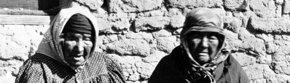
Tongva woman on the banks of the Los Angeles River.
Water Street: River of Dreams by Cherie Gaulke, 2003
Name Variations or Other Villages:
-Yaanga
-Yaa
-Yan-gna
-Yangra
-Yabit
-Yavit
Yorba Linda, California
Discoveries show that there may have been been Indians (Gabrielino) in the Yorba Linda area as early as 4,000 years ago.
http://www.yorbalindahistory.org/index.php
sources:
Handbook of the California Indians
Hugo Reid papers
Send additions, corrections or comments to sam@tongvapeople.com
Your feedback is appreciated………..Sam